

Brightwood Elementary Springfield
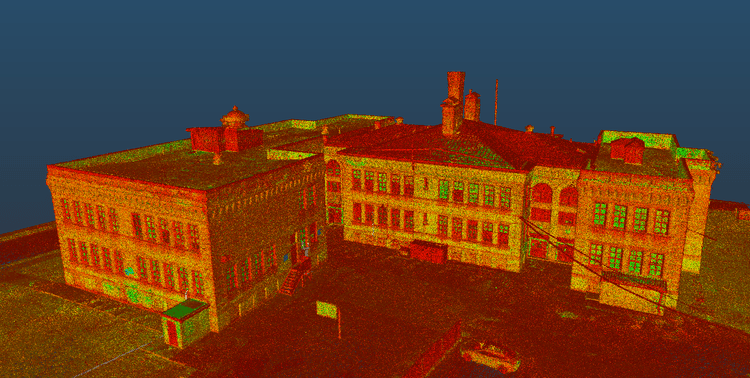
On Plainfield Street in Springfield, MA, Pointknown documented Brightwood Elementary School, a historic building originally constructed in 1898 and expanded in the early 20th century. The project focused on capturing the full structure and its architectural character to support renovation and future planning.
Springfield experienced a population explosion between the Civil War and the First World War. The Brightwood School and Homer Street School were both built-in 1898 to meet the growing need for education. Brightwood was designed by B. Hammett Seabury. The school was enlarged in the early twentieth century,
A complete existing conditions package, from reality capture to usable deliverables.
This project demonstrates the effectiveness of combining LiDAR scanning and drone-based capture to document complex historic structures efficiently. The integration of multiple data sources ensured that both fine architectural details and overall building geometry were preserved in a unified digital environment suitable for modern design workflows.


The value is not in the scan itself. It is in what your team can do next.
Design-ready deliverables
Measured information is structured into clean Revit and CAD outputs so architects, owners, and developers can move quickly.
Clear communication
Pointknown focuses on clarity. The process stays in the background. The usable result stays front and center.
One source of truth
A single field effort supports visualization, planning, modeling, and documentation—without repeated site visits or fragmented information.
If you are planning, renovating, leasing, or evaluating a building, clear existing conditions matter.
Pointknown helps design teams and property stakeholders move forward with confidence by turning existing buildings into usable, decision-ready information.